Monday, November 30, 2009
Indian Community
Waitman Worthington McDaniel lived in and around Cecil. Some of his history was recorded and can be found at the Taylor County Library. In a certain section entitled “Mound Builders” a prehistoric “house or fort” structure is described. According to the information given “one side of the enclosure is a natural cliff thirty high and semicircle in shape.” It also describes evidence of a battle that may have taken place in this area. Quoting the text, “the back of a human skulls, human bones, and human teeth are among the ghastly relics which have been picked up.” It is unclear whether when the battle took place before David Tygart and Robert Files settled in the Tygart Valley in 1753. Whether or not a battle actually occurred will probably never be known. However, it is clear that an indian settlement was located in the Pleasant Creek area. The pictures below are of what I believe to be the natural cliff described in the story.


Monday, March 30, 2009
The Tale of the Floating Church
I do not have definitive proof this event actually occurred, although some clues maybe gathered from the Federal Geographic Names Information System. According to the site found here the name of the church as been changed many times over its history. Some of the other names include Riverside Church and Cecil Church. These names seem rather odd considering the present location of the church miles from both a river and the location of Cecil. This evidence coupled with different sources speaking to it validity I tend believe the story to be true. The church in question can be seen in the following photographs. If anyone has any further information on the church please add a post or send an email.
Photos by K.A. Pitzer
Monday, March 16, 2009
Pre-Dam Maps
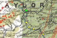
These map were created before the construction of the dam. It may be a testament to the size and importance of these small towns that they where placed on this maps. On the first map you can clearly see Yates, Stonehouse, Cecil, and Cove Run depicted on the map. The only town that may have existed but not placed on the map was the town of Sandy. It, however, can be seen on the second map along with Cecil and Yates.
Map #1 created in 1921

Map #2 created in 1922

Map #1 created in 1921
Map #2 created in 1922
Labels:
Cecil WV,
Cove Run WV,
Maps,
Sandy WV,
Stonehouse WV,
Yates WV
Sunday, February 1, 2009
Cecil Bridge
Areas once connected by bridges along the Tygart river where forever severed when the dam was built. The bottom half of Taylor County was in effect split in two by the rising river waters. Easy passage from one side of the river to the other was no longer possible. All of the connections forged between individuals or communities would be broken or drastically changed forever. This separation can be seen in a story that appeared in a local newspaper on June 24, 1937 describing the dismantling of the Cecil Bridge. According to the story, “dismantling of the Cecil bridge, made necessary by the construction of the Tygart Lake reservoir dam, has been ordered by the State Road Commission, and the span will be stored in its new location just about the Carr China company property in Park view.” The story goes on to state that the bridge would be re-erected near the “pottery.” It does not appear that the bridge was ever reassembled. There was, however, a small swinging bridge that connected Park View to the end of Maple Avenue. The remains can be seen in this photo. Connections between parts of the county where lost never to be rebuilt just like the bridge at Cecil.
Labels:
Bridge,
Carr China Company,
Cecil,
Maple Avenue,
Park View,
Taylor County,
Tygart Dam,
Tygart River
Tuesday, January 27, 2009
Train Schedule

This B & O train schedule describes the various stops traveling from Grafton to Belington. As you can see the train stopped in Cecil as well as Cove run both of which are now covered by water. The schedule neglects to mention the other three communities that where located down the valley. They may not have been large enough to deem necessary a train station. Cove run which is located in
Wednesday, January 21, 2009
Scene of Destruction
Saturday, January 17, 2009
Cecil Moved Away

Cecil was once a “happy and prosperous community that might some day become as large a city as Grafton.” In fact as many as 400 people once lived in the town of
This newspaper article puts a new twist on the story of this small town. The real danger to Cecil may not have been rising water but in fact the loss of jobs. It is unclear thus far in my research what happened to Cecil for the next eleven years before the flooding of the valley. This story does shed some light on the approximate size and the types of buildings located within the town.
*This may or may not be correct the document is difficult to read
Tuesday, January 13, 2009
Cecil Revealed
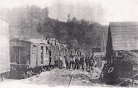
 This picture was taken in Cecil, WV around the turn of the century. Unfortunately the angle of the photo does not reveal much of the actual town, however, it does show a few buildings in the background as well as a some of Cecil's residents. Also notice the small "Cecil" sign in the middle of the picture. This photograph was found in the archives of the U.S. Corps of Engineers office located above the Tygart Dam.
Labels:
Cecil WV,
Tygart Dam,
U.S. Corps of Engineers
Wednesday, January 7, 2009
Honor Sage of Cecil

This news story was found in "The History of Taylor County" by Charles Brinkman Chapter 711a Pg. 253
Labels:
Cecil,
McDaniel,
The Grafton Sentinel,
Tygart Dam,
Tygart Lake Dam
Saturday, January 3, 2009
Four on the River
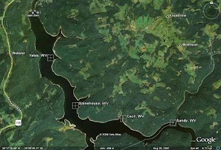
Before the construction of the Tygart Dam there where four small communities located within the valley that is now engulfed by the lake. The first, Yates, was located near the modern day swimming area of Tygart Lake. Stonehouse was the second located a little further up the lake about two coves down from Yates. The third was called Cecil and may have been the largest of four communities according to my preliminary research and it was located in modern day Hailslip Cove. Cecil as a whole my not have been swallowed up by the lake, however, it seemed to have disappeared from the maps after the forming of the lake. The fourth small town was referred to as Sandy and was located close to the lakes head waters. It appears to have been located around the line where the lake flows from Barbour into Taylor County. It is unclear thus far in my research if these locations where small towns or only small groupings of houses but what is clear is that they where once real places where people lived there lives.

As you can see I have added a map to give a better idea of the locations of these towns. I researched and found the coordinates of all four communities using the U.S. Department of Interior's Geographic Names Information System (GNIS).

As you can see I have added a map to give a better idea of the locations of these towns. I researched and found the coordinates of all four communities using the U.S. Department of Interior's Geographic Names Information System (GNIS).
Labels:
Barbour County,
Cecil WV,
Sandy WV,
Stonehouse WV,
Taylor County,
Tygart Dam,
Tygart River,
Yates WV
Subscribe to:
Posts (Atom)